
When designing roadways and communities to benefit an aging population, engineers and planners should consider the natural changes in vision, fitness and flexibility, attention span, and reaction time that may occur as we age. Making left turns or getting stranded in the crosswalk when the signal changes can be challenging for anyone, and especially challenging for an aging population. However, through the application of proven engineering and safety countermeasures it is possible to accommodate the needs of aging drivers, pedestrians, and bicyclists while enhancing the safety of everyone traveling Florida roads.
Building roadways and communities with Florida's aging population in mind is critical to meeting their current and future transportation safety needs. The resources on this page support Safe Mobility for Life's data-driven approach to eliminating fatalities and serious injuries for Florida's aging population. We will be adding more resources and guidance that directly supports engineers and planners as they become available. To receive a notification when these resources are posted, sign up for Safe Mobility for Life updates.
eTraffic
FDOT's State Traffic Engineering and Operations Office developed eTraffic, a GIS based web application, that integrates various FDOT traffic related datasets and is used for data reporting, analysis, and informational purposes. The datasets are reflected as interactive layers that can be activated or deactivated based on the need of the analysis. The Safe Mobility for Life eTraffic layer supports our proactive data-driven approach.

Countermeasures
The countermeasures and strategies shown in this section have been proven effective in reducing fatalities and serious injuries for the aging population and can benefit people of all ages. Open the sections below to view the specific countermeasures, find where you can access guidelines, along with available educational materials.
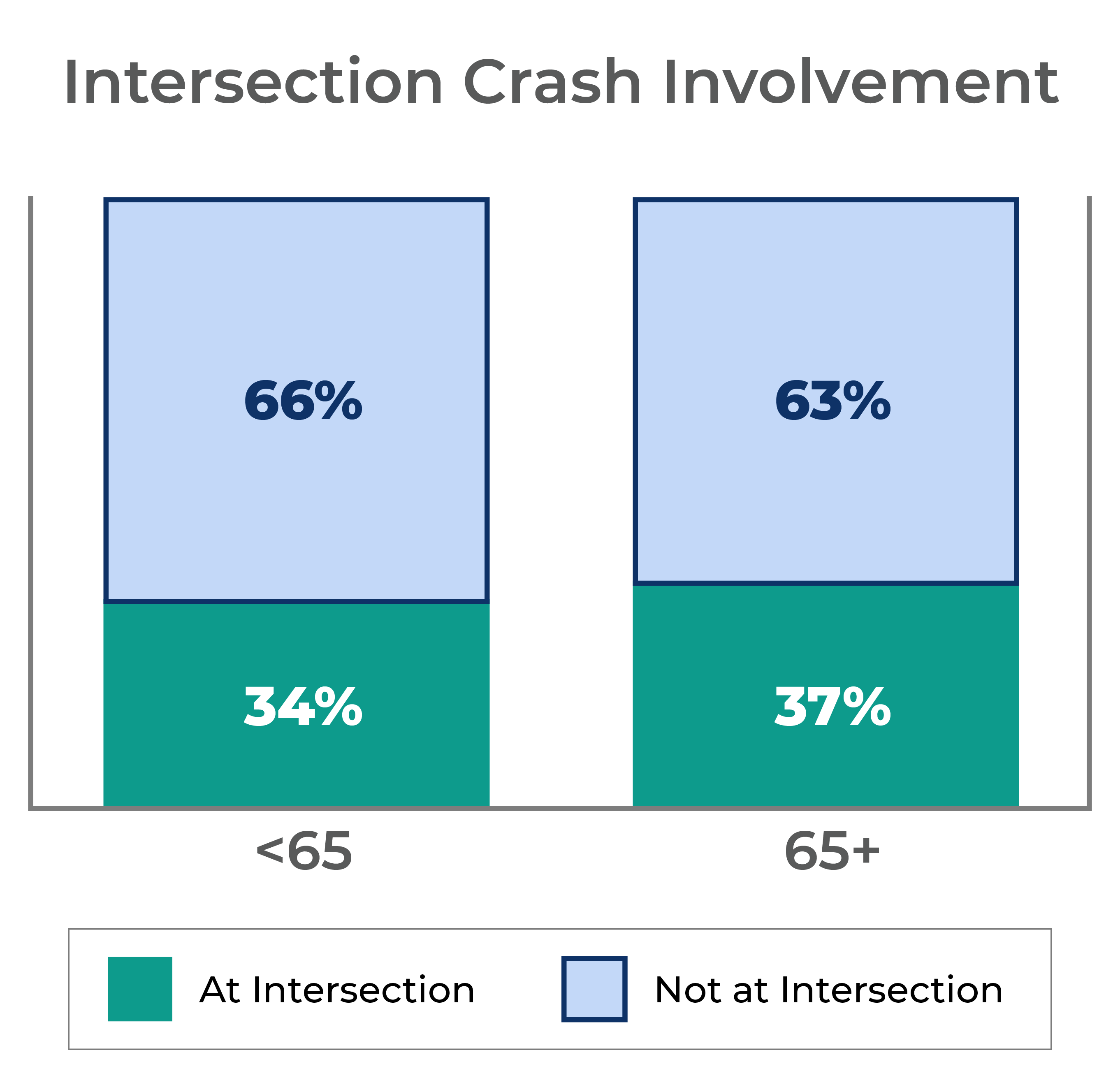
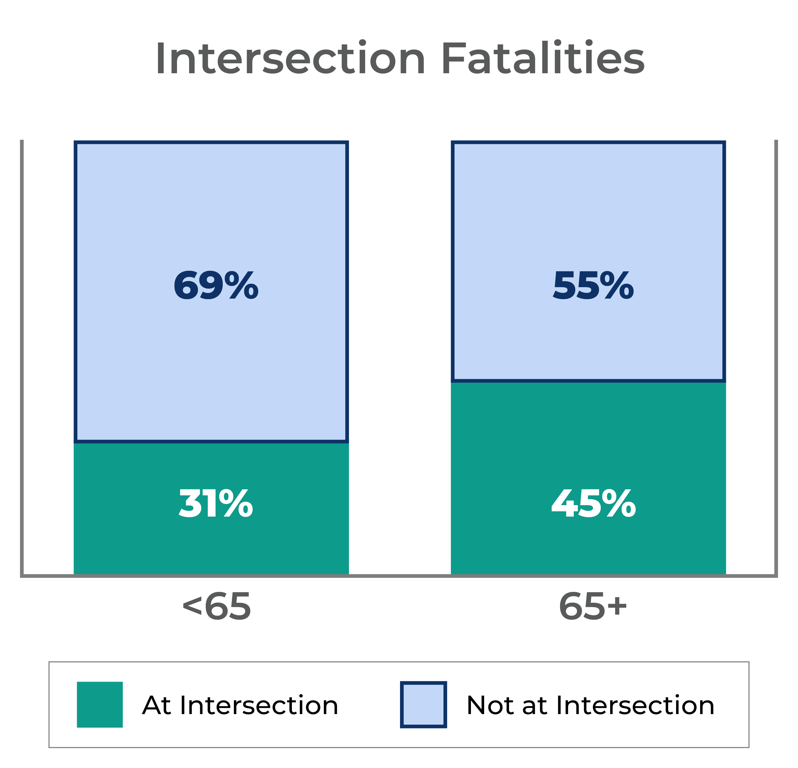
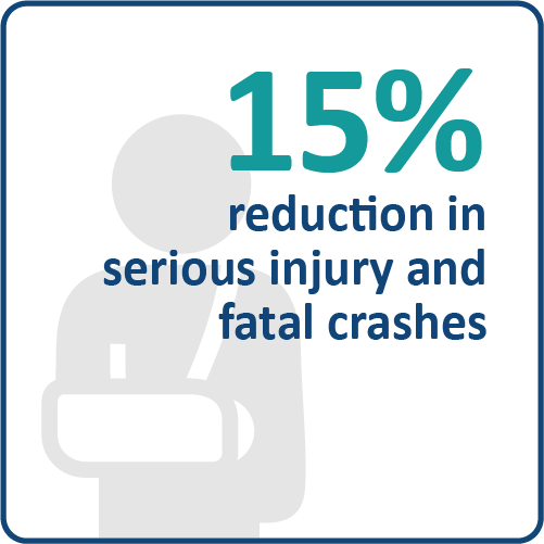
One particular challenge for aging drivers, is the ability to safely navigate intersections. While intersection-related crashes comprise a similar share of crashes for individuals over and under 65, they take a much greater share of fatalities for those aged 65 and over – showing they are more deadly for this age demographic as depicted in the image below.
Making left turns, changing lanes, and navigating through intersections are among the most complex traffic situations for aging drivers and require appropriate countermeasures and some are shown below to ensure safety.
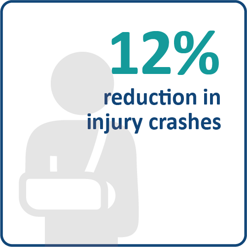
- Description: Traffic signals attract the attention of every driver, including aging drivers, those with impaired vision who meet legal requirements, who are fatigued or distracted, or who are not expecting to encounter a signal at a particular location. Backplates with retroreflective borders improve safety performance at signalized intersections. Yellow retroreflective borders may be used as an option to improve visibility of the illuminated face of the signal.
- Safety Benefits:
- Relevant Guidelines:
- Section 3.9, Installing Retroreflective Signal Backplates on Existing Structures, Stop and Yield Sign Sizes, Traffic Engineering Manual
- Chapter 2, Section 13C, Backplates, FHWA Handbook for Designing Roadways for the Aging Population
- Backplates with Retroreflective Borders, FHWA’s Proven Safety Countermeasures initiative (PSCi)
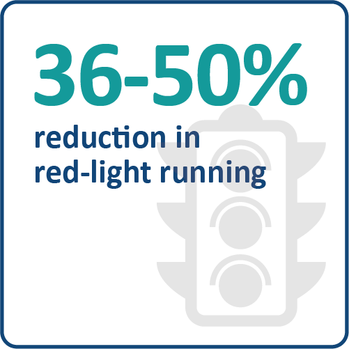
- Description: The flashing yellow arrow increases the likelihood that all drivers, but particularly aging drivers, will wait for an appropriate gap in oncoming traffic before beginning a permissive left-turn maneuver, rather than incorrectly assuming that they have the right-of-way. This results in a decrease in the likelihood of right-angle and other crashes that are particularly common among aging drivers making unprotected left turns. Research indicates an improved response rate for the flashing yellow arrow (FYA) among users of all ages, as compared to the circular green. Installation of the FYA indication for permissive left-turns provides a safety improvement when added to existing protected/permissive left-turn signal phasing operations.
- Relevant Guidelines:
- Section 3.10, Flashing Yellow Arrow Signal Application, Traffic Engineering Manual
- Chapter 2, Section 24, Flashing Yellow Arrow, FHWA Handbook for Designing Roadways for the Aging Population
- Education Material
- Flashing Yellow Arrow – Tip cards in English and Spanish can be viewed or ordered from the Safe Mobility for Life Resource Center.
- Flashing Yellow Arrow Educational Graphics can be viewed or downloaded from the Safe Mobility for Life Digital Resource Center.
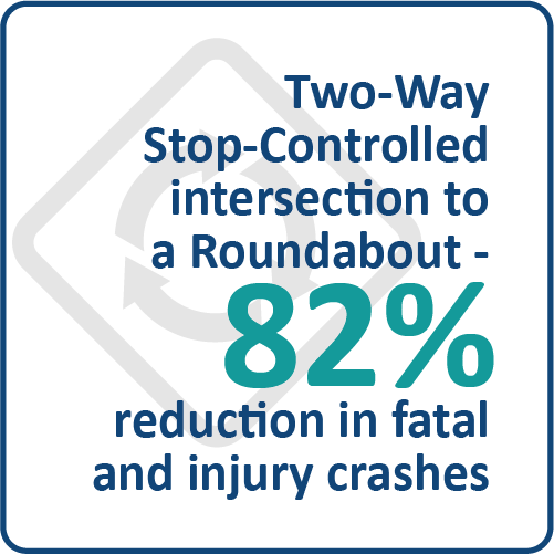
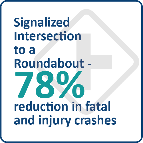
- Description: Roundabout intersections can be a beneficial treatment over a traditional stop- or signal-controlled intersection for aging drivers. When properly designed, roundabouts are low-speed intersections, effectively eliminate severe right-angle crashes, eliminate problems associated with making unprotected left turns at intersections. Therefore, roundabouts are recommended to be considered as part of the engineering study in the design of new intersections and the redesign of existing intersections.
- Safety Benefits:
- Relevant Guidelines:
- Section 213, Modern Roundabouts, FDOT Design Manual
- Chapter 2, Section 16, Roundabout, FHWA Handbook for Designing Roadways for the Aging Population
- Roundabouts, FHWA’s Proven Safety Countermeasures initiative (PSCi)
- Education Material
- How to Safely Navigate Roundabouts tip cards in English and Spanish can be viewed or ordered from the Safe Mobility for Life Resource Center.
- Roundabout Educational Graphics can be viewed or downloaded from the Safe Mobility for Life Digital Resource Center.
- Description: At a signalized intersection, the yellow change interval is the length of time that the yellow signal indication is displayed following a green signal indication. Appropriately timed yellow change intervals can reduce red-light running and improve overall intersection safety.
- Safety Benefits:
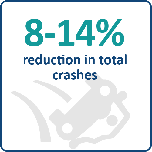
- Relevant Guidelines:
- Section 3.6, Standardization of Yellow Change and Red Clearance Intervals for Signalized Intersections, Traffic Engineering Manual
- Yellow Change Intervals, FHWA’s Proven Safety Countermeasures initiative (PSCi)
Approximately two-thirds of pedestrian- and bicyclist-related fatal crashes occur outside of a marked crosswalk or bicycle lane. Many serious and fatal injuries to pedestrians and bicyclists occur during dark or dusk hours. Motorist speed is one of the major factors that can mean the difference between a minor injury and a serious injury or fatality for a bicyclist or pedestrian. As speed increases, the likelihood of a crash with a bicyclist or pedestrian resulting in a fatality or serious injury also increases.
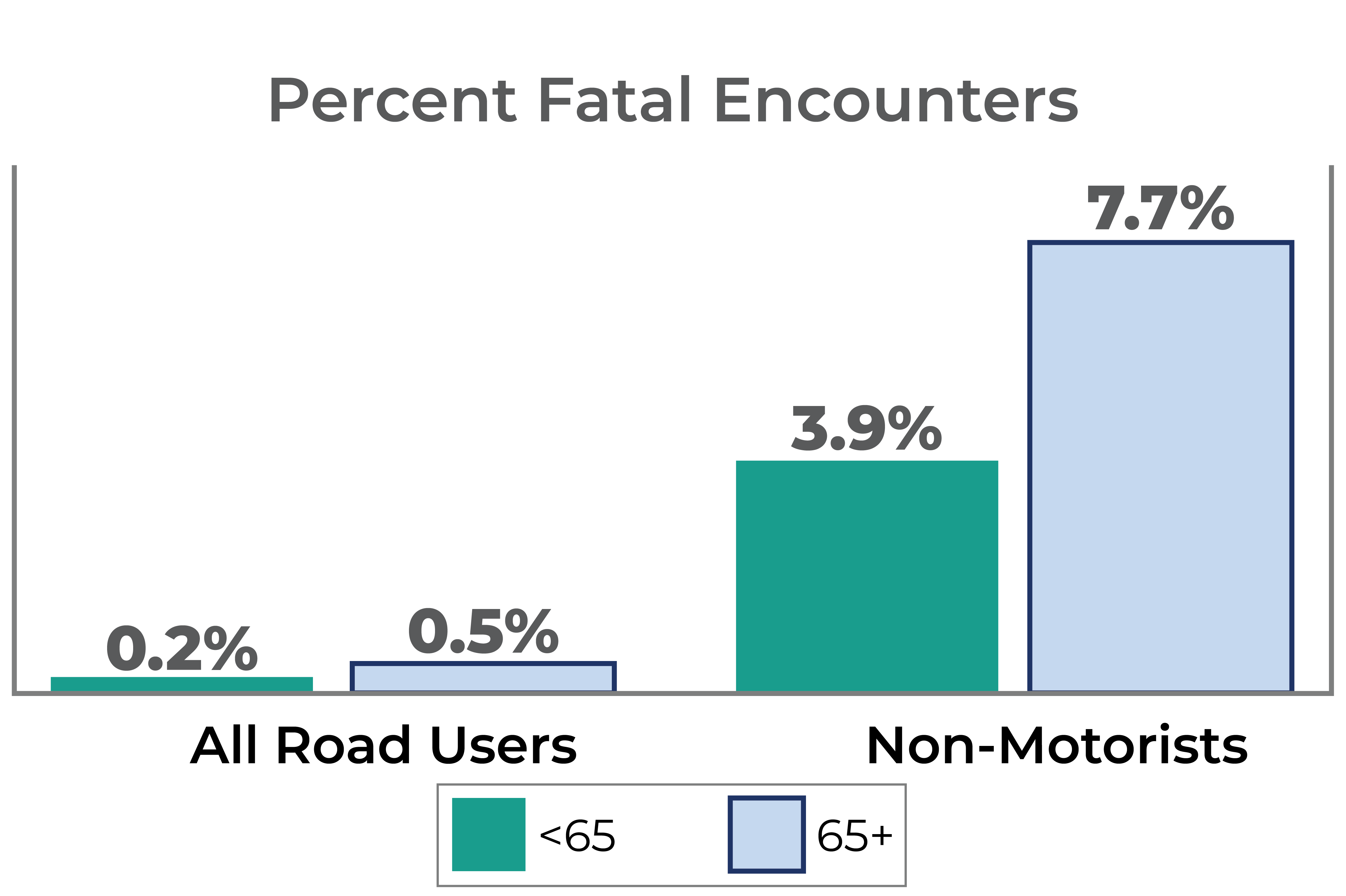
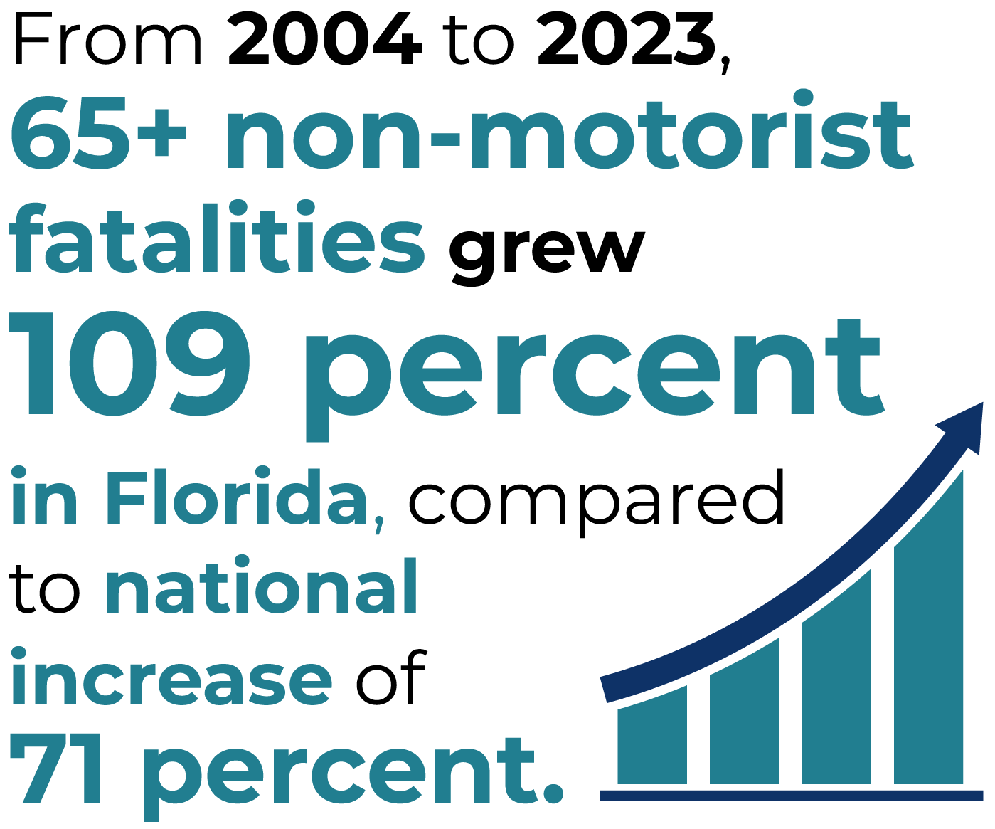
The likelihood of a non-motorist being killed in a crash is much higher than that of a motorist. Moreover, older non-motorists (65 and older) are more likely to die at a crash compared to those under 65. As indicated by the chart below, 7.7% of aging non-motorists involved in crashes died, compared to only 3.9% of non-motorists under 65. This also stands in contrast to figures under 0.5% of fatal encounters for all road users.
- Description: The pedestrian hybrid beacon (PHB) is a traffic control device designed to help pedestrians safely cross higher-speed roadways at midblock crossings and uncontrolled intersections. In general, PHBs are used where it is difficult for pedestrians to cross a roadway, such as when gaps in traffic are not sufficient or speed limits exceed 35 miles per hour. They are very effective at locations where three or more lanes will be crossed or traffic volumes are above 9,000 annual average daily traffic.
- Safety Benefits:
- Relevant Guidelines:
- Section 5.2.7.4, Beacons and Signals, Traffic Engineering Manual
- Pedestrian Hybrid Beacons, FHWA’s Proven Safety Countermeasures initiative (PSCi)
- Education Material
- Midblock Pedestrian Crossing with PHB Educational Graphics can be viewed or downloaded from the Safe Mobility for Life Digital Resource Center.
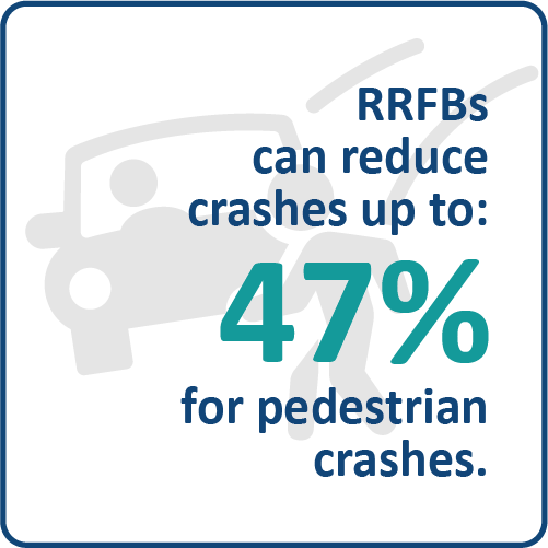
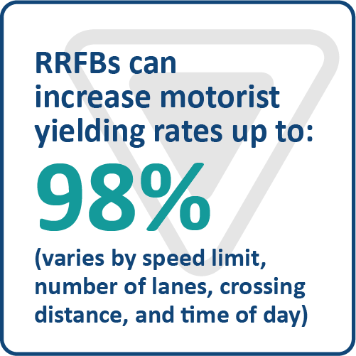
- Description: To enhance pedestrian conspicuity and increase driver awareness at uncontrolled, marked crosswalks, a pedestrian actuated Rectangular Rapid Flashing Beacon (RRFB) can be installed to accompany a pedestrian warning sign. RRFBs consist of two, rectangular- shaped yellow indications, each with a light-emitting diode (LED)-array-based light source. RRFBs flash with an alternating high frequency when activated to enhance conspicuity of pedestrians at the crossing to drivers.
- Safety Benefits:
- Relevant Guidelines:
- Section 5.2.7.3, Beacons, Traffic Engineering Manual
- Rectangular Rapid Flashing Beacons, FHWA’s Proven Safety Countermeasures initiative (PSCi)
- Education Material
- RRFB Educational Graphics can be viewed or downloaded from the Safe Mobility for Life Digital Resource Center.
Frequently Asked Questions
- eTraffic data is grouped across several tabs corresponding to specific FDOT initiatives, traffic characteristics inventory, Manual on Uniform Traffic Control Devices (MUTCD), interim approvals and requests to experiment. These include but are not limited to wrong-way driving, mid-block crossings, traffic signals, pedestrian crosswalks, network screening analysis, etc.
- Safe Mobility for Life has a dedicated tab in eTraffic that displays data layers to identify items such as priority intersections, priority counties, community partners, and target regions.
- Safe Mobility for Life Priority Intersections: Intersections identified to have high number of crashes in their respective categories, with special emphasis on those having fatalities or serious injuries.
- 65+
- Non-Motorist 65+
- Non-Motorist All Ages
- Alcohol-related (all ages)
- Percent of 65+ Licensed Drivers: Share of licensed drivers in each county that are 65+.
- 65+ Driver Involvement: Fatal Crashes involving a 65+ driver per 100,000 Licensed Drivers who are 65+.
- Urban Target Regions (for 65+ and non-motorist 65+): Areas that experience a higher number of motorist and non-motorist crashes for aging road users 65+ within urban counties.
- Rural Target Regions (for 65+ and non-motorist 65+): Areas that experience a higher number of motorist and non-motorist crashes for aging road users 65+ within rural counties.
- Safe Mobility for Life Priority Counties: Top 10 counties (for each Rural and Urban areas) having the highest rate of 65+ crashes relative to 65+ population.
- Percent of Population Aged 65+: Share of resident population in each county aged 65 and over.
- Vision Zero Communities: Communities recognized for their commitment to Vision Zero and have adopted a Vision Zero Action Plan.
- AARP Florida's Age-Friendly Network: Active Florida communities that are a member of AARP's Age-Friendly Network.
- Community Partners: Active community partners who have signed an agreement to work alongside Safe Mobility for Life to meet the safety and transportation needs of Florida's aging population through outreach and education.
- eTraffic allows us to visualize trends, crash events, and other data elements together to support Safe Mobility for Life's proactive, data-driven approach to reducing crashes, fatalities, and injuries to aging Floridians(65+). These are some examples of potential uses:
- To help with decision making regarding rural areas, the following Safe Mobility for Life layers can be overlayed to get a comprehensive picture of regions that might need intervention and available partners to implement it:
- Rural target regions
- Priority counties
- Community partners
- Priority intersections
- For decision making regarding distribution of non-motorized materials, the following Safe Mobility for Life layers can be overlayed to understand areas of opportunity to distribute them:
- Urban target regions (non-motorized)
- Priority counties
- Community partners
- Non-motorized priority intersections
- To understand the greater context about aging road user areas of concern, layers from the Safe Mobility for Life tab can be combined with those from other tabs. For instance, overlaying the Safe Mobility for Life priority intersections and Safe Strides to Zero candidate intersections would enable the analyst to see the interplay and overlap between the two and find opportunities for action.
- To help with decision making regarding rural areas, the following Safe Mobility for Life layers can be overlayed to get a comprehensive picture of regions that might need intervention and available partners to implement it:
- For instance, if someone is interested in aging road user trends and crash events, it may be of interest to look at the interplay between Priority Intersections for 65+layer versus Priority Intersections for All Ages Users layer. It is worth mentioning that layers from multiple tabs can also be combined. It could be interesting, for example, to visualize the Safe Mobility for Life intersections alongside the Safe Strides to Zero candidate intersections to identify common intersections or corridors of concern.
Sources: FLHSMV Closeout Data (data reflects records with known ages only), BEBR Population Estimates, FLHSMV Licensed Driver Data.
No Warranties: This site and its content is made available by the Florida Department of Transportation on an "as is", "as available" basis without warranties of any kind, express or implied.
Disclaimer of Liability: The user of this application and data assumes all responsibility and risk for the use of both. Under no circumstances, including negligence, shall the Florida Department of Transportation, or its employees be liable for any DIRECT, INDIRECT, INCIDENTAL, SPECIAL, EXEMPLARY or CONSEQUENTIAL DAMAGES, or LOST PROFITS that result from the use, misuse or inability to use the application and data. Nor shall the Florida Department of Transportation, or its employees be liable for any damages resulting from or related to reliance; mistakes, omissions, interruptions, deletion of files, computer viruses, errors, defects, or any failure of performance, communications failure, theft, destruction or unauthorized access to the application and data.